A988
| A988 | ||||
 | ||||
| From: | Gallatown (NT296943) | |||
| To: | Templehall (NT270938) | |||
| Distance: | 1.7 miles (2.7 km) | |||
| Met: | A92, A915, A910 | |||
| Former Number(s): | B926 | |||
| Now part of: | B981 | |||
| Traditional Counties | ||||
| Route outline (key) | ||||
| ||||
Route
The A988 was a short link road in the north of Kirkcaldy.
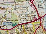
Starting at the Gallatown Roundabout with the A92 (now A921) and A915 the road headed westwards. Its first section was (and still is) D2 leading past an at-grade junction with Park Road, an access road to Michelston Industrial Estate. It then reached an at-grade roundabout with Overton Road and Carberry Road allowing access to St. Andrew's High School and ASDA. This is also where the D2 becomes S2.
The road continued westwards past Dunnikier Park to a signalised junction to access the ambulance station, Victoria Hospital and the Smeaton housing estate. It then passed Kirkcaldy High School and an access side road to Dunnikier House Hotel. The road, still heading westwards, then had a side road junction serving the crematorium and Dunnikier estate. The road then ended on a signalised junction where the former route of the A910 used to TOTSO between Hendry Road and Chapel Level.
History
On classification in 1922 the above was a rural, winding road to the north of Kirkcaldy which was given the B926 number. Over the years, as the spread of Kirkcaldy grew closer, the road was straightened and upgraded and, by the 1970s, was deemed worthy of a Class I number, becoming the A988. This status did not last long, however, and the road became part of the B981 following construction of the current A92 in the 1980s. It is still shown in the 1988 Readers Digest Atlas.
An image has been requested for this article.
