B6344
| B6344 | ||||
| Location Map ( geo) | ||||
| ||||
| From: | Rothbury (NU063018) | |||
| To: | Weldon (NZ136988) | |||
| Distance: | 5.6 miles (9 km) | |||
| Meets: | B6341, A697 | |||
| Highway Authorities | ||||
| Traditional Counties | ||||
| Route outline (key) | ||||
| ||||
The B6344 starts in Rothbury and heads eastwards along the Coquet valley.
The road starts on the B6341 to the east of Rothbury town centre and heads east, skirting the edge of the wooded Cragside Estate. Cragside itself (now owned by the National Trust) was the first private house in the UK to be built with electricity - hydro, I think....
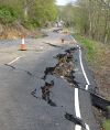
Presently the road reaches open country and contours to the east, between the hills to the left and river to the right. This is quite a steep hill and indeed there was a major landslip here in December 2012 and the road was not reopened till March 2016. From time to time the road gets closer to the river then moves away to avoid meandering with it. The road passes through no places of any size, although it goes through the hamlet of Pauperhaugh and passes a number of isolated buildings.
After passing the turn to Brinkburn Priory the road continues for over a mile to reach Weldon. It meets the original line of the A697 which marks the beginning of a GSJ to meet that road (despite the fact that both the A697 and B6344 are S2). The old mainline forms the northbound onslip whereas the road continues ahead to serve the other three movements, with the A697 crossing a bridge above.
| B6344 | ||
| ||
|


