Markham Moor
| Markham Moor | |||
| Location Map ( geo) | |||
 | |||
| |||
| Location | |||
| Markham Moor | |||
| County | |||
| Nottinghamshire | |||
| Highway Authority | |||
| National Highways | |||
| Junction Type | |||
| Dumbbell | |||
| Roads Joined | |||
| A1, A57, A638, B1164, C87 | |||
| Junctions related to the A638 | |||
| Junctions related to the B1164 | |||
Markham Moor is an important junction on the A1 in Nottinghamshire. It handles traffic for the main A1, traffic from Lincoln to Sheffield on the A57 (which multiplexes with the A1 as far as Apleyhead), and Retford traffic on the A638. It also handles local traffic from the B1164 and Markham Moor Service Area.
History
Before the major upgrades to the A1 in the late 1950s and early 1960s, the A1 Great North Road passed through the junction (then at-grade and staggered), using the now A638 to Retford and Doncaster. The A57 used the other two main arms. In 1957, the A57 to the west was dualled, ending at a roundabout just to the south of the old junction. When the A1 was diverted to meet the new A1(M) Doncaster bypass in 1961, the A1 used this western arm, as happens today. The A1 to the east came later, in 1967.
Work started in March 2007 and was completed in March 2009 to upgrade the junction from a roundabout to a full Grade-Separated Junction (GSJ) as part of the Blyth - Peterborough junction grade separation works. The junction is now in a standard dumbbell roundabout configuration, and the main A1 traffic flows smoothly through the junction.
For many years, on the approach from the south (locally actually the east-south-east) along the A1, there was an embankment between the separated carriageways as if in preparation for the future construction of a flyover. The layout eventually adopted, with the A1 underneath, was a fairly late change of design; a preferred route had previously been announced that involved the A1 on top. It is generally understood (although I have no confirmation) that the change in design allowed the Little Chef with listed roof to the north of the interchange to be preserved.
Strip Maps
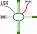
The old layout of Markham Moor, 1967-2008.
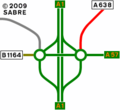
The current (post-2008) layout of Markham Moor.


Routes
| Route | To | Notes |
| Doncaster, Sheffield, Worksop (A57) | ||
| The SOUTH, Newark | ||
| Lincoln, East Markham | ||
| Retford | ||
| Ollerton | ||
| Milton, Walesby Lorry Park, Services | ||
| Sheffield, Worksop | ||
| Doncaster, Retford | ||
| Newark, Ollerton |
Links
National Highways
- Post Opening Project Evaluation - A1 Peterborough to Blyth - Grade Separated Junctions - Five Years After November 2015 (archive.org)
legislation.gov.uk
- The Al Trunk Road (A57, A638 and B1164 Junction Improvement Markham Moor) (Detrunking) Order 2006 - This SI removes trunk status with the completion of the works to grade separate the interchange


