A1 (Jersey)
| A1 | ||||
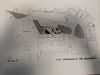
| Location Map ( geo) | ||||
| ||||
| From: | St Helier (XD921798) | |||
| To: | St Aubin (XD876791) | |||
| Via: | Millbrook, Beaumont | |||
| Distance: | 3.5 miles (5.6 km) | |||
| Meets: | A16, A17, A3, A9, A2, A10, A11, A2, A12, A13 | |||
| Highway Authorities | ||||
| Traditional Counties | ||||
| Route outline (key) | ||||
| ||||

The 'A1 in Jersey is an important road, although in places its route is somewhat baffling.
Jersey's A1 begins at the Weighbridge, where it intersects with the A16 and A17 (aka 'The Tunnel'). It passes along the D2-D3 Route de la Libération, which contains the only grade-separated junction in the Channel Islands, towards the A9. The GSJ is a simple roundabout with Underpass. Originally, this was a coastal route, travelling along the now-unclassified Esplanade and a gyratory around the abattoir (now the bus station). A car park and bus station were located at the Weighbridge. In the 80s, land was reclaimed in the south-west of St Helier, which involved the construction of the new road. At one point before the GSJ was decided there was a proposal to construct a large roundabout to connect the new relief road in front of the Albert Marina with the old route of the A1 along the Esplanade.
A mere half-mile from its eastern end at West Park, one encounters the A1's first oddity. It TOSTOs from the continuing D2 (A2 Victoria Avenue) at a traffic light junction and continues along the S2 La Route de St Aubin. In addition to the A2, it meets the B87 at a roundabout, which acts as a link road to the A9 and remainder of the St Helier Ring Road. This setup is odd because one would expect the A1 to be the most important route on the island. It is even stranger since it is doubtful the classification system predates the opening of Victoria Avenue at the end of the 19th century. It is likely classed initially as the A1 since it is St Aubin's Main Road. Instead, the A1 takes us on a traffic-choked urban route that runs to the north of the D2 road. There is a busy signalised junction to access the Avenue and the residential estates at First Tower as well as a staggered priority junction with the A10 Mont Félard at Millbrook in St Lawrence.
The decision to award this route to the A1 is even more baffling when we realise that it is not possible to continue onto the next section of the A1 at Bel Royal due to a bus gate. Previously, this junction had been a roundabout, however to organise traffic at some point in the 60s or 70s most traffic was restricted from continuing along the A1. If we had used the A2, it would have been possible to continue onto Beaumont, but instead we must continue onto the A11 and then use a series of narrow back roads to reach the next section.

The next part of the A1 is a continuation of the A2 and is very busy, as it leads up to one of the most important junctions on the island at Beaumont Village in St Peter. This junction, with the A12, is a 'Filter in Turn' arrangement. At this junction, drivers must take it in turns to 'filter' around the roundabout. It is more common in Guernsey, however exists in both islands. In the UK, this would not be possible, as it requires patience and consideration for drivers wanting to cross your path to turn onto the A12. Even for islanders it can cause confusion due to some irregularities in the markings. Originally this junction would have been a roundabout, however the amount of traffic coming from the A1 from the West is considerable, especially at rush hour, and the queues up the A12 were likely unacceptable if they were required to give way to the right as normal. Despite this, the junction has regular queues in all directions, particularly during the summer months. In the 1980s (as part of the 1986 Island Plan) there were plans to introduce a gyratory system in Beaumont. This would involve a new link road from Route de la Haule and Beaumont and the removal of the filter-in-turn.
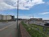
After this, we arrive in St Brelade we continue westwards on St Aubins Bay into St Aubin itself, where we terminate as the road turns sharply right and becomes the A13 towards Red Houses. Initially, the A1 continued along the St Aubin Harbour along Le Boulevard, but this road has since been detrunked. The entire route has a 30mph speed limit, except for the short section in St Aubin's village which has a 20mph limit with traffic calming, including 'Jersey-style' zebra crossings, which lack Belisha Beacons.