County Leitrim
Jump to navigation
Jump to search
| County Leitrim Contae Liatroma | |||
| Location Map ( geo) | |||
 | |||
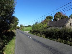
| The R207 heading north at Cornashamsoge | |||
| |||
| Current Highway Authorities | |||
| Leitrim County Council | |||
| Borders | |||
| Cavan • Donegal • Fermanagh • Longford • Roscommon • Sligo | |||
County Leitrim is the seventh smallest of the 32 counties of Ireland and the sixth smallest of the 26 which make up the Republic of Ireland. Situated in the Border Region and the north-eastern part of the province of Connacht, it is Ireland's least densely populated county. It has a coastline on Donegal Bay just 4 km long, and Lough Allen on the River Shannon effectively splits the county into two parts.
Public highways in County Leitrim – other than national roads, which are the responsibility of Transport Infrastructure Ireland – are managed by Leitrim County Council.
| Route | From | To | Length |
|
|---|---|---|---|---|
| N4 | Palmerstown | Sligo | 198.2 km | View |
| N15 | Sligo | Lifford Bridge (border) | 111.1 km | View |
| N16 | Sligo | Belcoo Bridge (border) | 47.6 km | View |
| R199 | Drummora Great | Ballinamore | 28.7 km | View |
| R200 | Derrynacreeve | Drumkeeran | 33.9 km | View |
| R201 | Belturbet | Drumsna | 49.8 km | View |
| R202 | Cloonturk | Drumkeeran | 38.1 km | View |
| R203 | Arvagh | Kivvy | 7.1 km | View |
| R204 | Calloughs | Ballinamore | 14.1 km | View |
| R205 | Kilnacreevy | Gortawee (border) | 13.1 km | View |
| R207 | Drumgorman | Mullaghahy | 33.9 km | View |
| R208 | Mahanagh | Killaneen | 18 km | View |
| R209 | Drumheckil | Fenagh | 15 km | View |
| R210 | Drumaleague | Drumcong | 1.9 km | View |
| R278 | Sligo | Cornalaghta | 12.6 km | View |
| R280 | Bundoran | Carrick-on-Shannon | 73.2 km | View |
| R281 | Kinlough | Glenfarne | 30.5 km | View |
| R282 | Manorhamilton | Dooard (border) | 13.3 km | View |
| R283 | Moneenshinnagh | Kiltyclogher (border) | 10.7 km | View |
| R284 | Tullynagracken South | Leitrim | 41.6 km | View |
| R286 | Sligo | Pollboy | 22.9 km | View |
| R287 | Sligo | Lisgorman | 25.6 km | View |
| R288 | Ardakip Beg | Sriff | 5.2 km | View |
| R289 | Cleen | Corderry | 5.9 km | View |
| R299 | Drumsna | Drumheckil | 7.7 km | View |
| R371 | Tomisky | Ballyleague | 25.6 km | View |
| R903 | Leitrim Road, Carrick on Shannon | Carrick on Shannon bridge | 0.52 km | View |
| T54 | Carrick-on-Shannon | Bundoran | View | |
| L112 | Lough Gill | Cushina | View | |
| L117 | South of Sligo | Gortgarrigan | View | |
| L133 | Boyle | East of Belmullet | View |
Key
Motorway
Primary Route
Non Primary Route
Former Motorway
Defunct Route
E Road
Future Motorway
Future Primary
Future Non Primary
Historical Route
Tourist Route
Roman Road
Unbuilt Motorway
Unbuilt Primary
Unbuilt Non Primary
National Cycle Network
Cycle Route
Eurovelo Cycle Route
Junctions
Main Article: Junctions in Leitrim
Bridges, Tunnels, and other Crossings
Main Article: Crossings in Leitrim


