County Kildare
Jump to navigation
Jump to search
| County Kildare Contae Chill Dara | |||
| Location Map ( geo) | |||
 | |||
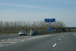
| Motorways diverge in County Kildare | |||
| |||
| Terminal & Intermediate Destinations | |||
| Athy | |||
| Other Important Destinations | |||
| Naas | |||
| Current Highway Authorities | |||
| Kildare County Council | |||
| Borders | |||
| Carlow • Dubin • Laois • Meath • Offaly • Westmeath • Wicklow | |||
County Kildare is located in the east midlands of Ireland. A landlocked county, it forms part of the province of Leinster and the Mid-East Region of the Republic of Ireland. Its closeness to the capital has made the county one of the fastest growing areas in the country: its population doubled in the period 1990–2005.
Public highways in County Kildare – other than national roads (including motorways), which are the responsibility of Transport Infrastructure Ireland – are managed by Kildare County Council.
| Route | From | To | Length |
|
|---|---|---|---|---|
| Dublin Outer Orbital Motorway | Navan | Newbridge | View | |
| M4 | Weston, near Leixlip | Heathstown, near Kinnegad | 46 km | View |
| M7 | Naas | Limerick | 195.6 km | View |
| M9 | M7 nr Newbridge | Grannagh | 115 km | View |
| N4 | Palmerstown | Sligo | 198.2 km | View |
| N7 | Dublin | Naas | 20 km | View |
| N9 | Grannagh | Waterford | .4 km | View |
| N78 | Hennebry's Cross | Mullamast | 50 km | View |
| N81 | Templeogue, Dublin | Closh Cross | 76.8 km | View |
| R125 | Swords | Kilcock | 46.2 km | View |
| R148 | Dublin | Heathstown | 70.7 km | View |
| R149 | Leixlip | Clonee | 8.0 km | View |
| R157 | Dunboyne | Maynooth | 12.1 km | View |
| R158 | Trim | Kilcock | 20.0 km | View |
| R160 | Ballynadrumny | Trim | 20.4 km | View |
| R401 | Rossan (Kinnegad) | Kildare | 42.3 km | View |
| R402 | Enfield | Ballina Cross | 45.0 km | View |
| R403 | Lucan | Carbury | 40.2 km | View |
| R404 | Leixlip | Saint Wolstans | 3.1 km | View |
| R405 | Maynooth | Newcastle | 5.8 km | View |
| R406 | Maynooth | Barberstown Cross | 6.7 km | View |
| R407 | Kilcock | Naas | 22.3 km | View |
| R409 | Blackwood Cross | Naas | 12.3 km | View |
| R410 | Naas | Blessington | 12.1 km | View |
| R411 | Naas | Hollywood | 14.0 km | View |
| R412 | Stephenstown South | Whitestown | 19.4 km | View |
| R413 | Kildare | Ballymore Eustace | 22.9 km | View |
| R414 | Shee Bridge, Allenwood | Monasterevin | 24.1 km | View |
| R415 | Allenwood Cross | Crookstown Upper | 39.6 km | View |
| R416 | Milltown | Kinneagh Cross | 9.1 km | View |
| R417 | Monasterevin | Carlow | 36.5 km | View |
| R418 | Knockaulin | Tullow | 47.2 km | View |
| R419 | Greatheath | Rathangan | 28.3 km | View |
| R424 | Lea Cross | Monasterevin | 5.2 km | View |
| R427 | Cashel | Cloney | 21.9 km | View |
| R428 | Stradbally | Athy | 12.3 km | View |
| R429 | Ballickmoyler | Maganey Cross | 6.8 km | View |
| R445 | Naas | Cratloemoyle | 168.0 km | View |
| R447 | Newbridge Road | Blessington Road | 2.9 km | View |
| R448 | Naas | Waterford | 124 km | View |
| R449 | Collinstown | Crodaun | 2.9 km | View |
| R747 | Mullamast | Arklow | 65.3 km | View |
Key
Motorway
Primary Route
Non Primary Route
Former Motorway
Defunct Route
E Road
Future Motorway
Future Primary
Future Non Primary
Historical Route
Tourist Route
Roman Road
Unbuilt Motorway
Unbuilt Primary
Unbuilt Non Primary
National Cycle Network
Cycle Route
Eurovelo Cycle Route
Junctions
Main Article: Junctions in Kildare
Bridges, Tunnels, and other Crossings
Main Article: Crossings in Kildare


