County Clare
Jump to navigation
Jump to search
| County Clare Contae an Chláir | |||
| Location Map ( geo) | |||
 | |||
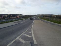
| The newly opened Ennis bypass, the N85, at Claureen | |||
| |||
| Terminal & Intermediate Destinations | |||
| Ennis • Ennistimon • Kilkee • Kilrush • Shannon | |||
| Current Highway Authorities | |||
| Clare County Council | |||
| Borders | |||
| Galway • Limerick • Tipperary | |||
County Clare lies on the west coast of Ireland, north and west of the River Shannon, in the province of Munster and the Mid-West Region of the Republic of Ireland.
Public highways in the county – other than national roads (including motorways), which are the responsibility of Transport Infrastructure Ireland – are managed by Clare County Council.
| Route | From | To | Length |
|
|---|---|---|---|---|
| M18 | Shannon | Athenry | 75.2 km | View |
| N18 | Shannon | Rossbrien | 21 km | View |
| N19 | Smithstown | Shannon Airport | 3.4 km | View |
| N67 | Galway | Tarbert | 141.9 km | View |
| N68 | Ennis | Kilrush | 40.6 km | View |
| N85 | Ennistimon | Kilbreckan | 31.9 km | View |
| R352 | Portumna | Ennis | 73.2 km | View |
| R445 | Naas | Cratloemoyle | 168.0 km | View |
| R458 | Kilcolgan | Smithstown | 65.5 km | View |
| R459 | Doolin | Doolin Pier | 2.2 km | View |
| R460 | Gort | Knockloskeraun | 49.7 km | View |
| R461 | Tiraloughan | Scarriff | 28.0 km | View |
| R462 | Tiraloughan | Cratloe | 41.6 km | View |
| R463 | Limerick | Tuamgraney | 38.3 km | View |
| R464 | Limerick | Parteen | 5.5 km | View |
| R465 | Parkroe | Bodyke | 23.2 km | View |
| R466 | Cloughan | Birdhill | 29.2 km | View |
| R467 | Clogher | Rosneillan | 4.3 km | View |
| R468 | Ballynahinch | Feakle | 6.6 km | View |
| R469 | Kilmurry | Ennis | 19.0 km | View |
| R470 | Newmarket on Fergus | Sixmilebridge | 9.5 km | View |
| R471 | Shannon | Cloonlara | 25.6 km | View |
| R472 | Newmarket on Fergus | Shannon | 6.0 km | View |
| R473 | Ennis | Kilrush | 51.4 km | View |
| R474 | Ennis | Milltown Malbay | 30.7 km | View |
| R475 | Carmody Street, Ennis | Kilrush Road Roundabout | 1.63 km | View |
| R476 | Fountain Cross | Lisdoonvarna | 30.8 km | View |
| R477 | Ballyvaughan | Lisdoonvarna | 30.0 km | View |
| R478 | Lisdoonvarna | Lehinch | 19.0 km | View |
| R479 | Ballynalackan | Coogyulla | 6.3 km | View |
| R480 | Ballyvaghan | Leamaneh Cross | 14.0 km | View |
| R481 | Kilfenora | Calluragh | 7.0 km | View |
| R482 | Fintra More | Dough | 4.5 km | View |
| R483 | Cloonadrum | Kilrush | 18.3 km | View |
| R484 | Caherfeenick | Knockalough | 15.8 km | View |
| R485 | Derrycrossaun Cross | Carrowniska | 5.7 km | View |
| R486 | Carrowbane | Killimer | 12.7 km | View |
| R487 | Kilkee | Loop Head | 27.0 km | View |
| R488 | Breaghva | Carrigaholt | 4.1 km | View |
| R496 | Kilmastulla | Killaloe | 4.3 km | View |
| R871 | Station Road, Ennis | Gort Road (R458), Ennis | 1.53 km | View |
| R912 | Newbridge Road, Ennis | Station Road, Ennis | 0.53 km | View |
| L193 | Newmarket on Fergus | Cloonlara | 28 km | View |
| L194 | North of Tulla | Scarriff | View | |
| L195 | Ballycorrick Bridge | Cahermurphy | View |
Key
Motorway
Primary Route
Non Primary Route
Former Motorway
Defunct Route
E Road
Future Motorway
Future Primary
Future Non Primary
Historical Route
Tourist Route
Roman Road
Unbuilt Motorway
Unbuilt Primary
Unbuilt Non Primary
National Cycle Network
Cycle Route
Eurovelo Cycle Route
Junctions
Main Article: Junctions in Clare
Bridges, Tunnels, and other Crossings
Main Article: Crossings in Clare


