Star.pngStar.pngStar grey.pngStar grey.pngStar grey.png

B1262

From Roader's Digest: The SABRE Wiki
Jump to navigation Jump to search
B1262
Location Map ( geo)
Cameraicon.png View gallery (2)
From:  St Catherine's, Lincoln (SK971695)
To:  Wigford Way / St Mary's Street, Lincoln (SK974709)
Via:  High Street
Distance:  0.9 miles (1.4 km)
Met (2016) A15, B1360, A57
Former Number(s):  A15
Highway Authorities

Lincolnshire

Traditional Counties

Lincolnshire

Route outline (key)
B1262 Link in Lincoln
This article is about the former B1262 in Lincoln.
For the original B1262 north of Scarborough, see B1262 (Scarborough - Burniston)
.
For a later B1262 west of Scarborough, see B1262 (Scarborough - East Ayton).
Looking north along Lincoln High Street

Until it was declassified in 2017 the B1262 ran along part of what had been the A15 southern approach to Lincoln.

The route left the A15 at a roundabout where that road bears right to bypass the city centre and ran north along what is known as the High Street (although it starts some 1.5 km from the city centre).

Shortly Dixon Street (another road which was declassified at the same – it had been the B1360) comes in from the left at traffic lights. Some maps still show the High Street as partly dual-carriageway but the central reservation was in fact removed in 2012. The church of St Peter at Gowts was passed (right), its tower having been visible for some distance, and, from this point on, the cathedral becomes very visible on the ridge ahead.

The former St Mark's railway station (closed in 1985 and now converted to use as a shopping centre) adjoins the left side of the High Street. The old level crossing has been removed but another remains a little further on, just west of Lincoln's other (and now only) station: the former Lincoln Central.

The B1262 ended at a traffic-light-controlled junction with Wigford Way / St Mary's Street (the A57). The High Street was pedestrianized beyond this point, and is now further closed to vehicular traffic beyond the St Mark Street / Tentercroft Street junction 150 m further south.


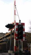

B1262
Related Pictures
View gallery (2)
Up the High Street - Geograph - 1504901.jpgLincoln High St LC - Coppermine - 4711.jpg
Other nearby roads
Lincoln
NCN1 • A15 • A46 • A57 • A156 • A157 • A158 • A607 • A1102 • A1162 • A1180 • A1190 • A1192 • A1434 • B199 • B1003 • B1131 • B1182 • B1188 • B1190 • B1193 (Lincoln) • B1194 • B1226 • B1273 • B1308 • B1360 • B1378 • B1398 • B1533 • B1536 • C970 (Lincolnshire) • C971 (Lincolnshire) • C972 (Lincolnshire) • C975 (Lincolnshire) • C976 (Lincolnshire) • C977 (Lincolnshire) • C978 (Lincolnshire) • C980 (Lincolnshire) • Ermine Street • EuroVelo 12 • Fosse Way • T44 (Britain) • T59 (Britain)
B1200 – B1299
B1200 • B1201 • B1202 • B1203 • B1204 • B1205 • B1206 • B1207 • B1208 • B1209 • B1210 • B1211 • B1212 • B1213 • B1214 • B1215 • B1216 • B1217 • B1218 • B1219
B1220 • B1221 • B1222 • B1223 • B1224 • B1225 • B1226 • B1227 • B1228 • B1229 • B1230 • B1231 • B1232 • B1233 • B1234 • B1235 • B1236 • B1237 • B1238 • B1239
B1240 • B1241 • B1242 • B1243 • B1244 • B1245 • B1246 • B1247 • B1248 • B1249 • B1250 • B1251 • B1252 • B1253 • B1254 • B1255 • B1256 • B1257 • B1258 • B1259
B1260 • B1261 • B1262 • B1263 • B1264 • B1265 • B1266 • B1267 • B1268 • B1269 • B1270 • B1271 • B1272 • B1273 • B1274 • B1275 • B1276 • B1277 • B1278 • B1279
B1280 • B1281 • B1282 • B1283 • B1284 • B1285 • B1286 • B1287 • B1288 • B1289 • B1290 • B1291 • B1292 • B1293 • B1294 • B1295 • B1296 • B1297 • B1298 • B1299
Earlier Iterations: B1204 • B1209 • B1217 • B1219 • B1221 • B1225 • B1226 • B1229 • B1241 • B1256(S)
B1256(N) • B1259 • B1260 • B1262(N) • B1262(W) • B1263 • B1266 • B1273 • B1292 • B1295 • B1296

SABRE - The Society for All British and Irish Road Enthusiasts
Discuss - Digest - Discover - Help