B1368
| B1368 | ||||
| Location Map ( geo) | ||||
 | ||||
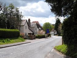
| High Street, Barley | ||||
| ||||
| From: | Puckeridge (TL386240) | |||
| To: | Hauxton (TL431518) | |||
| Distance: | 19.6 miles (31.5 km) | |||
| Meets: | A10, B1038, B1039, A505, A10 | |||
| Highway Authorities | ||||
| Traditional Counties | ||||
| Route outline (key) | ||||
| ||||
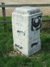
The B1368 is a cross-country B-road in the Home Counties, linking the A10 to itself along a shorter but more winding route. The road was originally unclassified but gained its number in the mid-1920s, and is shown on the 1925 Michelin map. An interesting feature of the B1368 is the presence of some of the oldest milestones in the country, dating from the 1720s and 1730s.
The road starts at a roundabout on the A10 Puckeridge bypass. It briefly follows that road's pre-bypass route towards the village before bending round to the left (priorities now favour the B1368) to head north. It crosses the River Rib and passes through Braughing (pronounced braffing) before continuing along the side of the valley of the River Quin.
In the village of Hare Street we are crossed by the B1038. A couple of miles further on we finally cross the River Quin, now little more than a stream, and then climb into Barkway, the largest place on the road so far. Newsells Park is then crossed and the road reaches the village of Barley. On the near side of the village the road bears sharply left; an unclassified road turns right here and quickly reaches the B1039, which road crosses us a short distance further on.
After crossing a small valley and then the Icknield Way the road meets the A505, crossing it at a staggered crossroads; this is the first time the B1368 has had to give way since leaving the A10. There's then a largely straight run to the northeast, with the exception of zigzags through Fowlmere and Newton. The road then bears left to cross over the Royston to Cambridge railway line; this is no mean feat as the land is now completely flat. On the far side we enter Hauxton and soon end at traffic lights back on the A10.


