B5017
| B5017 | ||||||||||
| Location Map ( geo) | ||||||||||
| ||||||||||
| From: | Burton upon Trent (SK240216) | |||||||||
| To: | Uttoxeter (SK094331) | |||||||||
| Distance: | 13.9 miles (22.4 km) | |||||||||
| Meets: | B5018, A5189, A5121, B5234, A515, A518 | |||||||||
| Primary Destinations | ||||||||||
| Highway Authorities | ||||||||||
| Traditional Counties | ||||||||||
| Route outline (key) | ||||||||||
| ||||||||||
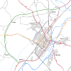
The B5017 is a pleasant country drive across the Needwood plateau and on through Highwood to the market town of Uttoxeter. A turnpike road.
The road begins in Burton upon Trent at the B5018, close by the Leicester line railway bridge (although its original eastern end was on the A38 High Street). It follows Anglesey Road to reach the A5189 at the south side of the main line railway bridge. There is then a short multiplex along the A-road across the railway bridge before the B5017 regains its number on meeting the A5121 at a roundabout improved in Autumn 2010. After going under the A38 the road strikes directly north-west up the Needwood escarpment to reach the plateau at the Acorn Inn (cyclists pause here!). Then it heads westerly along a very fast, almost straight, road to the New Inn, where there is a roundabout and filling station.
At this point the B5234 leaves us going west, and we enter the Needwood Forest (although woodland is hard to find, the area being largely enclosed in 1801). The road turns at this point to the north-west and takes a direct line to Six Lane Ends, where it meets the A515. Along the way it passes the remains of the Second World War aerodrome once known as RAF Tatenhill.
There is a short multiplex north along the A515 off the plateau into Draycott in the Clay, where the B5017 turns left to regain its number. The road now runs below bluffs known as Marchington Cliff, past the large former Ministry of Defence depot (now an industrial estate) on the right and past Netherland Green. The road swings north and climbs up and over Highwood before descending into Uttoxeter. The B5017 comes into the town to meet the A518 at a roundabout close by the Derby to Stoke railway line; originally it crossed the railway to end on the A518 Church Street.


