B849
| B849 | |||||||
| Location Map ( geo) | |||||||
| |||||||
| From: | Lochaline (NM678450) | ||||||
| To: | Bunavullin (NM556539) | ||||||
| Distance: | 10.6 miles (17.1 km) | ||||||
| Meets: | A884, Pier | ||||||
| Old route now: | A861, A884 | ||||||
| Highway Authorities | |||||||
| Traditional Counties | |||||||
| Route outline (key) | |||||||
| |||||||
The B849 is another of the roads in the West Highlands that really don't warrant a classification. It can be very lightly trafficked, especially away from the peak summer season when a few people will drive out and back just to explore the area. However, when the road numbers were allocated the Lochaline to Fishnish Ferry didn't exist (neither did the A884) and the pier at Bunavullin was just as important for these remote communities as the Lochaline Pier.
Route
The road starts at Lochaline, with two spurs joining the A884, one from the northern fringe of the village, and the other starting near its heart, passing a couple of small housing estates along the way. The two join next to the village church (with the northern road having to give way), and that is the final junction the route encounters for the next ten miles. From the church, the road follows the edge of the forest as it slowly drops down hill towards the coast. To the left is the Sound of Mull, with fine views across the channel to the Isle of Mull, and plenty of activity on the water most days, not least the ferries coming and going from the outer isles. To the right, the hills are clad in vast forests. At length, the road dips down to cross Savary Bridge, then climbs a little into the scattered settlement of Fiunary. There are a surprising number of houses spread along this remote coastline, with the Morvern estate and community working together to actively build more houses and businesses.
Another wee bridge is crossed at the western end of Fiunary as the meandering road makes a sharper left turn, and skirts round the edge of a hill. The flat, gently sloping ground between road and shore is the first evidence of the raised beaches found along the road, a result of changing sea level on a geological timescale. Further along, the land climbs steadily above the road to sudden cliffs marking another former shoreline or some other geological event from millions of years ago. A short distance further along the shore is another geological curiosity - Clach na Criche, the wishing or boundary stone, a remarkable wall like slab of stone protruding from the ground with a hole in it.
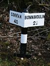
The road continues to wind north west along the shore, through scattered woodlands and small fields, with a few houses dotted along the roadside, and as many more hidden in the trees or down driveways. It passes the ruinous Caisteal nan Con on its little promontory at Bagh Caisteal, and then turns inland a little to cross the Killundie River. Despite the increased distance from civilisation, more and more houses are now passed, with the road now running almost due north at times, as it continues to follow the shore, but now at some distance. After ten uneventful miles, where the most significant junctions are private driveways, the road finally comes to another public road, the short unclassified road that drops down to serve a dozen or so properties at Bunavullin. A quarter of a mile later, the B849 terminates at the jetty which still provides an occasional passenger ferry to Tobermory on Mull. Private drives continue north-westwards to Drimnin, with a poor-relief road (now an untarred estate road with incongruous mileposts) of 1880 running for another 8 miles to a semi-derelict croft on the shores of Loch Sunart.
History
The 1922 Road Lists state that the B849 started some distance to the north, at Drimsallie on the A830 near Kinlocheil, and headed south to Lochaline, along what is now the A861 and A884. The A861 was only the second number to be added after the original 1922 list was completed, so the B849 appears to have been curtailed after perhaps only 12 months; however, the A884 number dates from around 1930, so it seems that that part of the original route at least lasted a little longer.
However, the original 1922 route does not include any of the modern route, and at present it is unclear exactly when the Lochaline - Drimnin road became part of the B849. It was, however, almost certainly included before the A884 was created on the section from Loch Sunart (to the east of Strontian) to Lochaline. The present route, including both spurs in Lochaline, is shown on the 1932 Ten Mile Road Map and the road is unchanged since then.
The current route of the B849 almost certainly dates from 1880, as with its continuation beyond Drimnin. The mileposts are of the same style, and there is no evidence that the road was built any earlier. Indeed, the whole route from Loch Sunart, including the A884 falls into this presumption. Prior to the construction of the road, the majority of traffic would have been water borne, with rough paths connecting the farms and cottages together on land. Wheeled traffic was little known in the Highlands before 1800, and only ever developed after the construction of roads, so would only have arrived in the remoter areas like Drimnin when the road were built. The bulk of traffic remained by boat until well into the twentieth century.


