B840
| B840 | ||||
| Location Map ( geo) | ||||
| ||||
| From: | Cladich (NN099223) | |||
| To: | Carnassarie Castle (NM842008) | |||
| Distance: | 23.7 miles (38.1 km) | |||
| Meets: | A819, A816 | |||
| Highway Authorities | ||||
| Traditional Counties | ||||
| Route outline (key) | ||||
| ||||
The B840 is a long B-road in Mid Argyll, following the southern shore of Loch Awe for much of its length.
Route
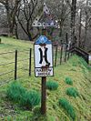
The road starts at a junction with the A819 near the village of Cladich, and winds down the hill to cross the Cladich River in the village. Just across Cladich Bridge a no entry road continues ahead while the B840 turns sharp to the right. This one-way road is the other half of the former A819 route through the village, and was until recently classified as a spur of the B840 on maps. It is also the last junction for nearly 20 miles! There are signs just past the junction describing the road as narrow and advising drivers to allow others to overtake, and until recently a pre-Worboys sign prohibiting large vehicles from the road. Climbing steadily out of the village through woodland and small fields, the road crosses the Archan River on a concrete bridge alongside the old stone arch, now hidden by trees. After a couple more bends, the highest point of the road is reached at 140m. It then drops steadily down past Ardbrecknish and into the strung out village of Portsonachan, where the shore of Loch Awe is met.
At the Portsonochan Hotel, old slipways line up with those on the north side of the loch and show the old ferry point to the B845 at North Port, Kilchrenan, which stopped over 50 years ago. A short climb takes the road through the western end of the village, before the road drops back to the shore again. From here the road heads in a south westerly direction following the southern shore of Loch Awe, often closely. From time to time it climbs over bumps, or turns inland around patches of shoreside grazing land, but mostly the road is on the shoreside. However, the density of the woodland makes views of the loch difficult to come by, unless you pull into a layby and take one of the many fishermen's paths down to the shore.
For two miles the road continues through trees with hardly a property to be seen. The loch becomes narrower, reaching its narrowest point as the road turns to the south, and then curves around a shallow bay at Balliemeanoch. There are occasional houses and farms again now, but chalets and static caravans seem to be more common, mostly privately owned holiday retreats. At Blarghour the road turns inland to cross the burn, but then stays away from the loch as it climbs a little through a forest to Ardchonnel. As the road regains the shore a group of small islands lie close in to the shore, the first home to Ardchonnel Castle, an ivy-clad ruin which is only accessible by boat. The last is the largest, with the ruins of the old chapel serving the communities at this end of the loch.
A small bay has to be navigated around the outlet of the Kames River at Barr More, with the mothballed Ardchonnel School nearby. Then it is into the forest again and up the hill to the tiny settlement of Eredine, whcih mostly lies above the road in the trees. For the next mile, the road remains further inland than before, but after crossing the Abhainn a Bhealaich at Durran it rejoins the shore for most of the way to Ford. The road is still heavily wooded, although as with so much of the route the resulting colours of the Bluebells, Wild Garlic and other flowers under the canopy of trees is quite beautiful in spring and early summer. Just before reaching the head of the loch, the road turns inland once more, crossing more low hills to Ford.
Eventually, and doubtless to great relief, the village of Ford is reached. The road crosses the bridge over the River Ford and then turns round to the left outside the Ford Hotel, where the minor road down the north side of Loch Awe from Dalavich meets it. This route eventually leads back to the B845 at Kilchrenan, quite a detour without the ferry! The narrow winding pass which the road now winds through was once, millennia ago, the outlet of Loch Awe before the Pass of Brander was breached at the opposite end of the loch. Today it is home to the small Loch Ederline, beyond which a left turn to Kilmichael Glassery turns off, but it is now just over a mile to go to the end of the B840 on the A816 in the shadow of Carnassarie Castle.
History
Very little has changed on the B840 since it was first classified, to the extent that until recently there were still a small number of pre-worboys signs along the route! However, as noted above, the route has been extended in Cladich. In 1922, the A816 passed through the village, the bypass being opened in the 1950s. This means that the B840 originally started at the junction at the centre of the village. There are a few places along the route where it has been widened a little, although primarily to provide more passing places, especially on some of the blind crests and bends. The only other noteworthy change is that the B840 no longer meets the B845 at Portsonachan. The ferry slip survives, but the ferry ceased operating in the 1950s, if not before, and it is doubtful if it ever carried cars.


