B790
| B790 | ||||
| Location Map ( geo) | ||||
 | ||||
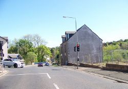
| The A761 in Bridge of Weir, where the B790 branches off the the left at the lights | ||||
| ||||
| From: | Bridge of Weir (NS385659) | |||
| To: | Inchinnan (NS465679) | |||
| Distance: | 5.3 miles (8.5 km) | |||
| Meets: | A761, B789, A726 | |||
| Highway Authorities | ||||
| Traditional Counties | ||||
| Route outline (key) | ||||
| ||||
The B790 is a short B-road in central Renfrewshire, which runs from the centre of Bridge of Weir to Barnsford Toll Junction on the A726 at Inchinnan Business Park, near Glasgow Airport.
Route
Bridge of Weir
The route starts at traffic lights on the A761 (former B788) near the centre of Bridge of Weir and heads east along Houston Road. At first modern flats look across at a block of trees on the left, but soon the route is passing through a council housing estate. A few private houses and a fairly large park on the left mark the edge of the village. Houston Road is wide enough for parking bays on both sides for much of its length, but as it reaches the last houses, it noticeably narrows. Down to the right, opposite the park, Houstonhead Dam can be seen across a field, while the road continues a fairly straight course north east across a short stretch of countryside between Bridge of Weir and Houston. At the end of the straights, the route climbs a little and sweeps round to the right. Originally the road went straight on and through the village here, but now bypasses it to the south.
Now following Bridge of Weir Road (the old route being renamed Old Bridge of Weir Road), the route curves to the south of the high school and then runs more or less parallel with the old alignment for half a mile or so. Fields lie to the south at first, but beyond the school housing has filled in the space between the old and new roads, with the B789 coming in from the left at a T junction. The two routes then multiplex for around 400 metres, curving through trees past a cemetery to a roundabout where the B789 turns right into Crosslee. Despite still following the bypass alignment, the B790 now feels more suburban, with housing estates leading off to right and left, interspersed with woodland. None of the houses actually face onto the road, but there are easy enough to see through the trees and bushes. The old alignment joins again on the left at the outskirts of the village and a little beyond the trees give way to fields once more.
The route continues east, and after a few wiggles it finds a long straight across low-lying and mostly flat land, but a short rise with a blind summit at Loanhead. There are a scattering of farms and houses along the roadside, with the River Gryffe meandering across the fields to the south, and a large area of mixed woodland on the left towards the end of the straight. The crop here is traditionally rhubarb and giant stalks of it can be seen in the fields when it is in season in late spring and early summer. In the woods to the north, the remains of ROF Bishopton (munitions and propellant factories) are gradually being cleared and replaced by housing, although not much can be seen from the B790. Part of the site is still owned by BAE Systems, who have facilities there, hence the high fence around it. Just after the C4 joins on the right, a gated entrance to BAE is located on the left, where a third lane has been added the B790 to assist right turns. A pair of tighter bends beyond the junction have double white lines, and bring the road closer to the river.
The road then runs along the north bank of the River Gryfe for a short distance before going under the Inverclyde Line railway at the site of the former Houston and (earlier) Georgetown stations. A second bridge in quick succession passes under the M8 - the gap between the bridges is shorter than the motorway is wide! After passing under the bridges, the route continues dead-straight for another few hundred yards before passing a Territorial Army depot on the right and a former NATS building on the left. It then ends at Barnsford Toll, which is a T-junction on the A726 at the edge of Inchinnan Business Park near Glasgow Airport.
History
The growth of the small village of Houston into a sizeable commuter settlement which has merged with nearby Crosslee, led to the construction of the Houston Bypass, although it is questionable if it is still a bypass as it now runs through the middle of the modern village. The old core of Houston was designated as a conservation village in 1968, and although the 1974 OS One Inch map doesn't show any additional development, by the end of the 1980s new estates had sprung up and the bypass was opened.
Pre-1960s OS maps show that the original road continued straight through Barnsford Toll Junction (the area now occupied by Inchinnan Business Park), connected up with Allands Avenue and ran to the India of Inchinnan tyre factory, where it ultimately reached the A8. This was never part of the B790, however.
| B790 | ||
| ||
|


