Star.pngStar.pngStar grey.pngStar grey.pngStar grey.png

M62 (Stretford - Eccles bypass)

From Roader's Digest: The SABRE Wiki
Jump to navigation Jump to search
M62
Location Map ( geo)
Cameraicon.png View gallery (2)
From:  Eccles (SD745006)
To:  Stretford (SJ790934)
Distance:  6 miles (9.7 km)
Now part of:  M60, M63
Traditional Counties

Lancashire

Route outline (key)
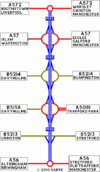
M62 Stretford – Eccles
Junction List
Junc Westbound Eastbound
A575, A572 Start of Motorway
A57 A57
B5214 B5214
Unclassified Unclassified
B5213 No Exit
Start of Motorway A56
This article is about the original use of the number, the Stretford-Eccles bypass (now M60 junctions 7 to 13).
For the Transpennine motorway from Liverpool to near Hull, see M62
.
For the 1990s proposal to build an express motorway from junction 12 to junction 18, see M62 Relief Road.
Globe.png
For detailed information about this topic, see Pathetic Motorways
On the 1967 Ordnance Survey Route Planning Map, junctions are shown as numbered from south to north, consecutively as 1-6.

The original use of the M62 number was for the Stretford-Eccles Bypass in Lancashire to the west of Manchester. It was renumbered to M63 in 1968, before being renumbered again to M60 in 1999.

It is located between the modern junction 7 and 13 of the M60.

There is an amount of confusion as to whether the junctions on the M62 were ever numbered. A number of maps by various providers (such as Ordnance Survey, an example of which is shown to the left) showed junction numbers starting with 1 at the southern end (now M60 J7), moving consecutively to 6 at the northern end, with no spare numbers left for the then-planned M52 South Lancashire Motorway and M60 AltrinchamSaleStretford Bypass. Other sources suggest that this is incorrect, and that the junctions were only numbered (in the opposite direction) once the motorway had been renumbered to M63.


M62 (Stretford - Eccles bypass)
Junctions
Crossings
Places
Related Pictures
View gallery (2)
Original M62 strip map.PNGManchester area from Johnston's Handy Road Atlas of GB and NI 1964 - Coppermine - 23648.jpg
Other nearby roads
Stretford
Sale
A56 • A6144 • A6144(M) • B5166 • B5311 (Sale) • B5397 • B6544 • M60 • M60 (Knutsford - Manchester) • M63 • M68 • T18 (Britain)
Trafford Park
A576 • A5081 • A5181 • B5158 • B5211 • B5214 • B5216 (Trafford) • B5217 • M60 • M63 • Trafford Park Motorway
Motorways in Great Britain
Current MotorwaysM1 • M2 • M3 • M4 • M5 • M6 • M6 Toll • M8 • M9 • M11 • M18 • M20 • M23 • M25 • M26 • M27 • M32 • M40 • M42 • M45 • M48 • M49 • M50 • M53 • M54 • M55 • M56 • M57 • M58 • M60 • M61 • M62 • M65 • M66 • M67 • M69 • M73 • M74 • M77 • M80 • M90 • M180 • M181 • M271 • M275 • M602 • M606 • M621 • M876 • M898
A1(M) • A3(M) • A8(M) • A14(M) • A38(M) • A48(M) • A57(M) • A58(M) • A64(M) • A66(M) • A74(M) • A92(M) • A167(M) • A168(M) • A194(M) • A195(M) • A308(M) • A329(M) • A404(M) • A601(M) • A627(M) • A635(M) • A666(M) • A823(M) • A1058(M) • A1077(M)
Motorway Spurs • (M4 Heathrow Spur • M25 T5 Spur • Walton Summit M'way)
Former MotorwaysM10 • M15 • M16 • M30 • M41 • M52 • M62 • M63 • M64 • M65 • M68 • M85 • M110 • M111 • M270 • M274 • M531 • M600
A2(M) • A4(M) • A5(M) • A8(M) • A11(M) • A18(M) • A20(M) • A21(M) • A23(M) • A36(M) • A40(M) (Central London) • A40(M) (Buckinghamshire) • A41(M) • A46(M) • A48(M) (Morriston) • A48(M) (Port Talbot) • A65(M) • A102(M) (North) • A102(M) (South) • A423(M) • A446(M) • A604(M) • A638(M) • A696(M) • A1231(M) • A6127(M) • A6138(M) • A6144(M)
Unbuilt MotorwaysM4 Toll • M12 (Woodford - Brentford) • M12 (Woodford - Maplin) • M12 (Brentwood - -Chelmsford) • M13 • M17 • M19 • M31 • M58 • M59 • M60 • M62 RR • M64 • M81 • M82 • M83 • M100 • M272 • M601 • M650
A2(M) • A6(M) (West) • A6(M) (East) • A14(M) • A48(M) • A59(M) • A61(M) • A556(M) • A695(M)
A Ring • Bilston Link • Belmont Link • B-W M'way • CME Bypass • CMW • Central Spine • Chippenham Spur • Coventry N-S M'way • Cublington Airport M'way • Denham Spur • Derby Urban M'way • Droitwich-Leicester M'way • East Coast M'way • EXR • East Kilbride M'way • E-W Underground M'way • Eastern M'way • Euroroute • Friars Goose Xing • Furness Link • Glasgow IRR • GM Western Relief Road • Hamilton-Cumbernauld M'way • Hook Road • Johnstone M'way • Kendal Link • Liverpool Inner M'way • LOX M'way • Malvern Radial • Manchester IRR • Morecambe Link • NE Urban M'way • NXR • N&W M'way • Paisley-Hamilton M'way • POLO • Princess P'way M'way • Reading Urban M'way • Ringway 2 • Sheffield Spur • S Bristol Spur • SCRPDR • SXR • Stirling Corner Link • Strensham-Solihill M'way • Strensham-Solihill M'way • TGAAR • Townhill Link • Trafford Park M'way • Warndon Radial • Watford Urban M'Way • Western Orbital • Weston Spur


SABRE - The Society for All British and Irish Road Enthusiasts
Discuss - Digest - Discover - Help