A5027
| A5027 | ||||||||||
| Location Map ( geo) | ||||||||||
| ||||||||||
| From: | Victoria Hospital, Birkenhead (SJ303914) | |||||||||
| To: | Upton (SJ264891) | |||||||||
| Distance: | 5.9 miles (9.5 km) | |||||||||
| Meets: | A5088, B5145, A59, A5139, B5146, A5030, A553, B5151, A551, B5139, B5192, M53 | |||||||||
| Primary Destinations | ||||||||||
| Highway Authorities | ||||||||||
| Traditional Counties | ||||||||||
| Route outline (key) | ||||||||||
| ||||||||||
The A5027 is an urban A-road towards the northern end of the Wirral.
Route
_Roger_May_-_Geograph_-_47266.jpg)
The road starts on the A5088 by the Victoria Hospital and heads roughly south. It crosses the A59 Kingsway Tunnel approach road, then a short section of dual carriageway connects it to Birkenhead Docks, which it crosses at the Duke Street bascule bridge. Shortly afterwards, the A5027 crosses the railway line adjacent to Birkenhead Park station and meets the A553.
The A5027 multiplexes west-by-northwest with the A553 for a short distance, the park on the left, then regains its number and continues skirting the park whilst heading west-by-southwest. It zigzags to descend Bidston Hill before crossing the M53.
The A5027 goes round three sides of the suburb of Upton before meeting the M53 again at the western end of the Moreton Spur, where it ends.
History
In 1922, the A5027 ran only between the A553 at Birkenhead Park and the A551 in the centre of Upton. The section through the docks (but not including the Duke Street Bridge which remained unclassified for many years) as far as the A5028 (current B5145) appeared around 1935 and it was later extended further with the building of the Kingsway Tunnel.
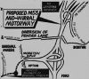
At the western end A5027 is now routed along the bypass of Upton which between the M53 bridge and the first roundabout follows the line of Ford Way, a road built in the 1960s. It uses a gap which appears to have been specially reserved until the southern bypass was opened on 12 December 1983 to finish on the B5139 Old Greasby Road.
It was extended northwards to M53 J2A Moreton Spur end, north of Upton, in 1991. The plans for this section date back to 1967 although then it was a connection from Moreton Spur to Saughall Massie Road to provide links to West Kirby and Hoylake. It got as far as approval in 1971 but nothing came of it until it was resurrected in the current scheme in the late 1980s.
_Colin_Pyle_-_Geograph_-_3139601.jpg)
_George_Robinson_-_Geograph_-_588922.jpg)
_William_Starkey_-_Geograph_-_3965532.jpg)
_Raymond_Knapman_-_Geograph_-_3107430.jpg)