Star.pngStar.pngStar grey.pngStar grey.pngStar grey.png

B5231

From Roader's Digest: The SABRE Wiki
Jump to navigation Jump to search
B5231
Location Map ( geo)
Cameraicon.png View gallery (1)
From:  Pendlebury (SD780025)
To:  Patricroft (SJ764984)
Distance:  3.1 miles (5 km)
Meets:  A666, A6, A572, B5229, A57
Highway Authorities

Salford

Traditional Counties

Lancashire

Route outline (key)
B5231 Pendlebury - Swinton Park
(A572) Swinton Park
B5231 Swinton Park - Monton
(B5229) Monton
B5231 Monton - Patricroft
Bridge carrying the M602 over Green Lane (the B5231) and the Bridgewater Canal in Monton

The B5231 is an urban B-road in west Salford.

The road starts at traffic lights on the A666 in the west of Pendlebury and heads south along the residential Station Road, which goes over the Manchester to Wigan railway line by Swinton station. A short distance further on the road reaches the centre of Swinton and crosses the A6 at traffic lights near the civic centre.

The B5231 continues south along Partington Lane back into the suburbs. At the end of this road there is a T-junction on the A572 and the B5231 multiplexes west for a short distance (crossing the A580 at traffic lights en route). The B5231 then regains its number and heads south through Dales Brow, a narrow suburb sandwiched between two golf courses. After a few hundred yards the road reaches Monton Green and a roundabout on the B5229.

There is a short multiplex west along the B5229 to the next roundabout before the B5231 heads south once more. The Bridgewater Canal is quickly met and the road and canal run parallel for a short distance, going under the same bridge under the M602. After road and canal separate the B5231 goes under a railway line by Patricroft station. After bending to the left it ends at traffic lights on the A57.
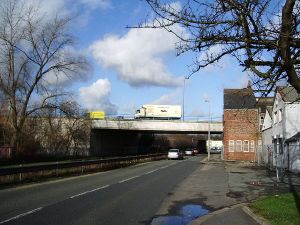


B5231
Related Pictures
View gallery (1)
The M602 crosses the B5231 - Geograph - 681085.jpg
Other nearby roads
Salford
A6 • A34 • A57 • A526 (Newcastle-under-Lyme - Salford) • A563 (Liverpool - Salford) • A572 • A575 • A576 • A580 • A665 • A666 • A5063 • A5064 (Salford) • A5065 (Salford) • A5066 • A5104 (Swinton - Worsley) • A5185 • A5186 • A6010 • A6041 • A6042 • A6044 • B5211 • B5221 • B5225 • B5226 • B5227 • B5228 • B5229 • B5230 • B5232 • B5234 (Lancashire) • B5341 (Salford) • B5461 • B6181 • B6182 • B6183 • B6184 (Salford) • B6185 • B6186 • B6187 • City Centre Road • E20 • E22 • E109 (Old System) • M52 • M60 • M61 • M62 • M62 Relief Road • M64 (Eccles - Salford) • M601 • M602 • Manchester Inner Ring Road • T12 (Britain) • T21 (Britain)
B5200-B5299
B5200 • B5201 • B5202 • B5203 • B5204 • B5205 • B5206 • B5207(W) • B5207(E) • B5208 • B5209 • B5210(W) • B5210(E) • B5211 • B5212 • B5213 • B5214 • B5215 • B5216 • B5217 • B5218 • B5219
B5220 • B5221 • B5222 • B5223 • B5224 • B5225 • B5226 • B5227 • B5228 • B5229 • B5230 • B5231 • B5232 • B5233 • B5234 • B5235 • B5236 • B5237 • B5238 • B5239
B5240 • B5241 • B5242 • B5243 • B5244 • B5245 • B5246 • B5247 • B5248 • B5249 • B5250 • B5251 • B5252 • B5253 • B5254 • B5255 • B5256 • B5257 • B5258 • B5259
B5260 • B5261 • B5262 • B5263 • B5264 • B5265 • B5266 • B5267 • B5268 • B5269 • B5270 • B5271 • B5272 • B5273 • B5274 • B5275 • B5276 • B5277 • B5278 • B5279
B5280 • B5281 • B5282 • B5283 • B5284 • B5285 • B5286 • B5287 • B5288 • B5289 • B5290 • B5291 • B5292 • B5293 • B5294 • B5295 • B5296 • B5297 • B5298 • B5299
Earlier iterationsB5208 • B5211 • B5215 • B5216 • B5222 • B5233 • B5234 • B5255 • B5258 • B5264(S) • B5264(N)
B5271 • B5276 • B5279 • B5280 • B5282 • B5288 • B5290(N) • B5290(S) • B5293(W) • B5293(E) • B5299

SABRE - The Society for All British and Irish Road Enthusiasts
Discuss - Digest - Discover - Help