Star.pngStar.pngStar grey.pngStar grey.pngStar grey.png

B4532

From Roader's Digest: The SABRE Wiki
Jump to navigation Jump to search
B4532
Location Map ( geo)
Cameraicon.png View gallery (1)
From:  Monument Road (SP048861)
To:  Calthorpe Road (SP054855)
Via:  Highfield Road
Distance:  0.6 miles (0.9 km)
Meets:  B4124, A456, B4284, B4217
Highway Authorities

Birmingham

Traditional Counties

Warwickshire

Route outline (key)
B4532 Link in Birmingham
Birmingham Oratory

The B4532 is a short link road in Edgbaston, Birmingham. Owing to the road's short length its history is not fully known but it may date back to the 1930s. However, the 1938 OS 1:10560 sheet suggests that at that time the route was a spur of the B4217. This could either be an error, or suggest that that route changed and the map was not updated to reflect this.

The road leaves the B4124 Monument Road as Plough and Harrow Road: a one-way street heading southeast. Shortly after passing the Birmingham Oratory on our right, we meet the A456 Hagley Road at traffic lights by the Plough and Harrow Hotel. The route of the B4532 zigzags left then right but vehicles are prohibited from making the right turn.

The B4532 continues as the two-way Highfield Road, It intersects the B4284 Harborne Road before ending on the B4217 Calthorpe Road at a set of traffic lights next to the church of St George, Edgbaston.

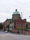


B4532
Related Pictures
View gallery (1)
Geograph-4665236-by-Gordon-Griffiths.jpg
Other nearby roads
Birmingham
A34 • A38 • A38(M) • A41 • A42 (Reading - Birmingham) • A45 • A47 • A435 • A441 • A452 • A453 • A455 (Birmingham - Stafford) • A456 • A457 • A458 • A4027 • A4028 • A4029 • A4030 • A4040 • A4097 • A4123 • A4166 • A4167 • A4400 • A4540 • A4723 • A5127 • B38 (Selly Oak) • B384 • B3800 • B4025 • B4043 • B4096 • B4100 (Birmingham) • B4114 • B4118 (Birmingham) • B4120 • B4121 • B4122 (Birmingham) • B4123 • B4124 • B4125 • B4126 • B4127 • B4128 • B4128 (Suffolk Street, Birmingham) • B4129 • B4129 (Birmingham City Centre) • B4130 • B4131 • B4132 • B4133 • B4134 • B4135 • B4136 • B4137 • B4140 • B4141 (Birmingham) • B4142 • B4143 (Birmingham) • B4144 • B4145 • B4146 • B4147 • B4148 • B4167 • B4182 • B4217 • B4284 • B4498 • B4514 • B4515 • B4516 • B4531 • B4533 • B4552 • B4730 • E05 • E24 • E28 (Birmingham - Ipswich) • E33 (London - Glasgow) • E116 (Old System) • Holyhead Road • Longest Lane • M5 • M6 • M40 • M42 • M600 • Northern and Western Motorway • Ryknild Street • T13 (Britain) • T14 (Britain) • T15 (Britain) • T16 (Britain) • T35 (Britain) • T53 (Britain)
B4500 – B4599
B4500 • B4501 • B4502 • B4503 • B4504 • B4505 • B4506 • B4507 • B4508 • B4509 • B4510 • B4511 • B4512 • B4513 • B4514 • B4515 • B4516 • B4517 • B4518 • B4519
B4520 • B4521 • B4522 • B4523 • B4524 • B4525 • B4526 • B4527 • B4528 • B4529 • B4530 • B4531 • B4532 • B4533 • B4534 • B4535 • B4536 • B4537 • B4538 • B4539
B4540 • B4541 • B4542 • B4543 • B4544 • B4545 • B4546 • B4547 • B4548 • B4549 • B4550 • B4551 • B4552 • B4553 • B4554 • B4555 • B4556 • B4557 • B4558 • B4559
B4560 • B4561 • B4562 • B4563 • B4564 • B4565 • B4566 • B4567 • B4568 • B4569 • B4570 • B4571 • B4572 • B4573 • B4574 • B4575 • B4576 • B4577 • B4578 • B4579
B4580 • B4581 • B4582 • B4583 • B4584 • B4585 • B4586 • B4587(N) • B4587(S) • B4588 • B4589 • B4590 • B4591 • B4592 • B4593 • B4594 • B4595 • B4596 • B4597 • B4598 • B4599
Earlier iterationsB4500 • B4504 • B4528 • B4529 • B4534 • B4544 • B4553 • B4557 • B4558

SABRE - The Society for All British and Irish Road Enthusiasts
Discuss - Digest - Discover - Help